water
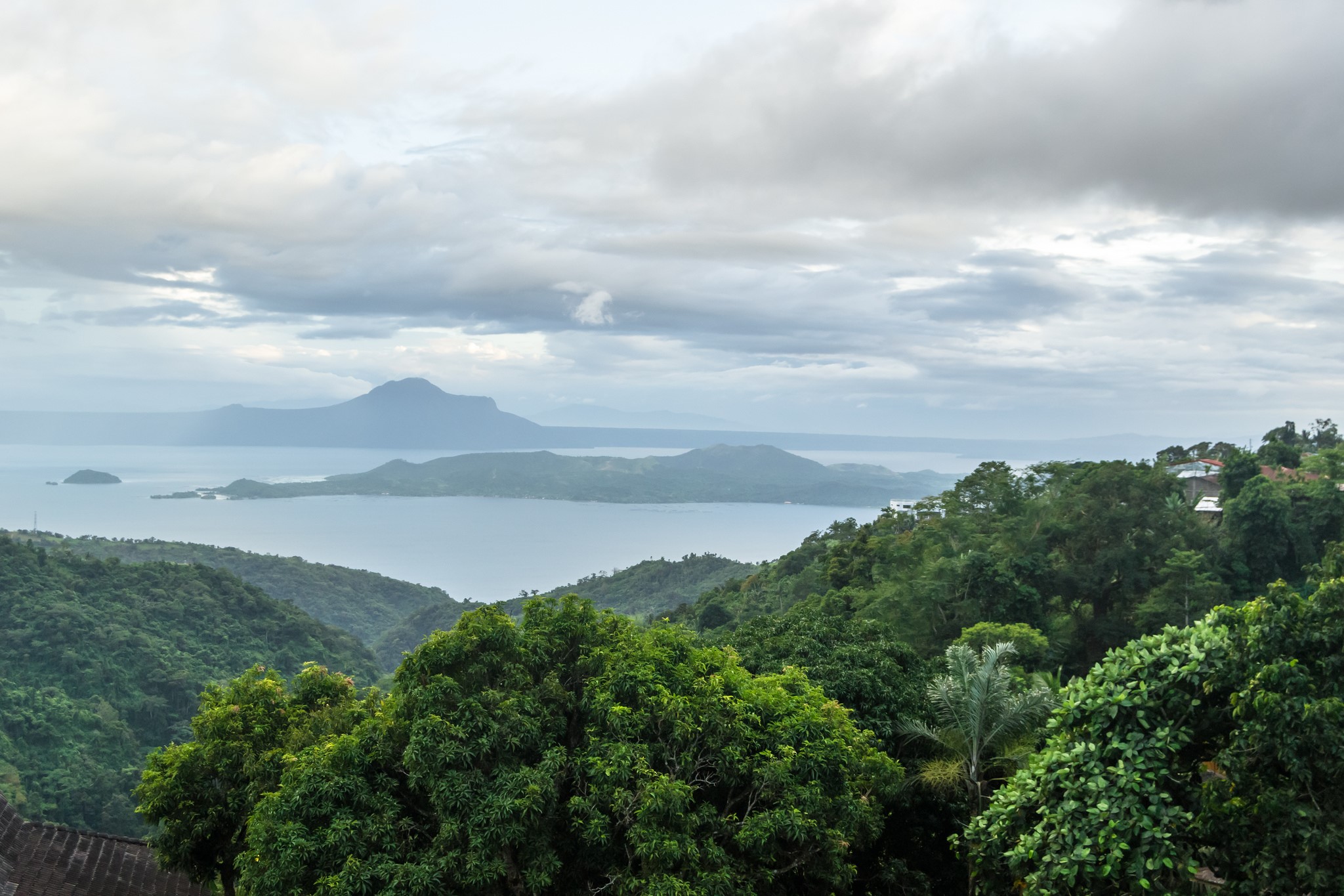
Understanding the Role of Forests in Supporting Livelihoods and Climate Resilience (and Twin Goals) in the Philippines
CHALLENGE
Tremendous progress has been made in reducing poverty over the past three decades. Nonetheless, more than 1 billion people worldwide still live in destitution. In addition, rising prosperity in many countries is accompanied by social exclusion and increasing inequality. The post-2015 Development Agenda has thus made reducing poverty its priority. The new World Bank strategy reinforces this objective, aiming to end extreme poverty in a generation and to promote shared prosperity for the bottom 40 percent. These goals will only be achieved if development is managed in an environmentally, socially, and fiscally sustainable manner.
The challenge for development is that the poor are often highly dependent on natural resources, such as forests. Although forests provide ecosystem services and safety nets for the livelihoods of the poor, forests are facing significant pressures from the range of sectors that are critical for economic growth, such as agriculture, transport and energy. Therefore, if sustainably managed, forests could play a significant role in achieving the twin goals of reducing poverty and building climate resilience. However, our understanding of this dual forest-poverty relationship is limited, which this study seeks to address..
APPROACH
This study focuses on the Philippines where, similar to many tropical countries, extensive deforestation and forest degradation have taken place over the last century due to logging, fires and other human disturbances, which are further aggravated by climate change. The country’s total forest cover has declined to merely 6.9 million hectares, or 23% of the total land area.
This study builds on the three primary roles that environmental income plays in supporting rural livelihoods: (i) supporting current consumption; (ii) providing safety nets to smooth income shocks or offset seasonal shortfalls, as well as impacts of climate change; and (iii) providing the opportunity to accumulate assets and exit poverty. Each of these roles is examined further in how they depend on and impact the ecosystem services provided by forests (including the impacts of climate change), and how they can help reduce extreme poverty and promote shared prosperity for the bottom 40%. Three case study sites were examined: the Upper Marikina RIver Basin Protected Landscape (UMRBPL), the Libmanan-Pulantuna Watershed (LPW), and the Umayam, Minor and Agusan Marsh Sub-basin (UMAM).
RESULTS
- Higher forest cover generates higher water yields during the driest months of the year.
- If the water regulating services provided by forests were to be replaced by delivered water, the expected costs would be USD 419-1,064 per household per year, depending on the study site. These costs will be prohibitive to most households in the study sites as the majority subsist below the poverty line.
- Compared to a “no forest” scenario, forest reduce the volume of floodwater by 27% to 47% during the three wettest months of the year. Forests on steep slopes (>30%) help mitigate the risk of erosion by 68% to 99% per hectare, and have the potential to reduce annual sediment outflows from watersheds by 7 to 100 times compared to bare soil.
- Replacing erosion and sediment control services with manmade control measures will cost billions of pesos. Reforestation is a lower-cost alternative to securing erosion regulation ecosystem services over the medium term.
- Water was cited by poor upland communities as the most important subsistence benefit from the forest, which they use for domestic purposes and, in some instances, for irrigation.
- Upland communities in UMRBPL reported that about 7% of their annual cash income comes from the sale of forest resources like bamboo products, charcoal, fish, and bush meat. Approximately 40% of their annual income comes from the sale of farm produce grown on forested land.
- Forests also provide fuelwood and wood for charcoal, which supplies most of the communities’ energy needs.
- Poorer households in upland communities rely more on forest resources for income and subsistence
The study concludes with a list of recommendations for landscape planning and forest management:
- Incorporate ecosystem service modeling and valuation, forest use analysis and scenarios in forest land use planning and forest management.
- Improve access of upland and forest dwelling communities to forest resources.
- Enhance the value of forest assets by internalizing non-market values and adding value to the existing sources of income.
For stories and updates on related activities, follow us on twitter and facebook , or subscribe to our mailing list for regular updates.
Last Updated : 06-16-2024
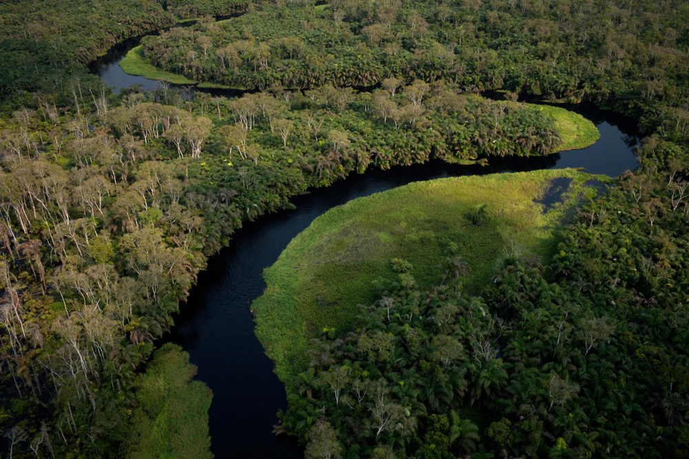
Understanding the Forest-Water Interactions in the Congo Basin
PROGRAM SUMMARY
The development objective of this project is to improve the understanding of forest-water interactions in the Congo Basin across World Bank project teams, client countries and climate scientists in Africa, and to strategize potential application to development programs and policies in the region. The analysis seeks to use emerging data and research to identify links between forest loss and degradation and water resources in the Congo Basin in the context of climate variability, covering impacts both locally and from a regional hydrologic cycle perspective.
CHALLENGE
The Congo Basin represents roughly 70% of Africa’s forest cover and is the second largest contiguous tropical forest in the world after the Amazon Basin. The Congo Basin provides many ecosystem services (carbon and non-carbon) but the forests are under pressure from economic activity such as logging, agriculture, energy, transport, and mining, and satellite-based data show that annual rates of deforestation have doubled since 1990 (World Bank 2013). Climate change is predicted to impact the Congo Basin significantly: since the 1950's, the region has experienced a 1°C increase in mean annual temperature (Niang et al. 2014; Fuller et al. 2018); by the 2080's, climate models suggest temperatures will increase 3 to 5°C and precipitation will decrease by 40% (Fotso-Nguemo 2016).
Understanding the impacts of forest loss within the Congo Basin and regionally is limited due to limited information on the linkages between forest loss and environmental services in the Congo Basin, particularly of the role of the forest in generating rainfall both locally and regionally. While much of the research related to the impact of tropical forests on rainfall and temperature has been undertaken in the Amazon, the few studies that have been conducted in the Congo Basin indicate that the region is a major source (17%) of moisture for West Africa (Cadet and Nnolli; Gong and Eltahir). One study estimates that the rain forests of West Africa may account for 30-40% of the annual rainfall in the Ethiopian highlands (Ellison 2018). Others suggest that the main source of rainfall in the Congo Basin is evaporation from the Great Lakes and that the Congo forest basin in turn generates much of the rainfall not only in the Congo basin (75-95%) (Brinkman 1983 in Job 1994) but also in the Sahel (van der Ent et al. 2010). At the same time, the drying trend in the Basin suggested by some scientific papers (Zhou et al. 2014) may impact this “water pump” service it provides. Such impacts are well described for the Amazon, where scientists have warned of an “Amazon dieback” or “savanization” of the Amazon (Vergara and Scholz 2011).
APPROACH
- The activity expanded the available evidence base through the production of an innovative online, interactive e-book. This e-book/knowledge portal houses both a data and analytics portal for the Congo Basin across numerous social, economic, and environmental themes; and a knowledge portal containing relevant literature, reports, investments, videos and programs in the Congo Basin.
- Community of Practice Formed. The team held numerous consultations (both in-person and virtually) with Bank teams working within the region, relevant academic experts, donor and other organizations. The CoP distribution list developed had over 200 people and is expected to be useful for the future as well.
- Two global virtual discussions undertaken. The first discussion session was held in September 2019 with over 50 participants; a smaller, more focused session was held in December 2019 with about 20-25 participants.
For stories and updates on related activities, follow us on twitter and facebook , or subscribe to our mailing list for regular updates.
Last Updated : 06-16-2024
Share
Attachments
Keywords
Authors/Partners
ISRIC World Soil Information and Wageningen UR
Targeting Watershed Rehabilitation Investments in Turkey
CHALLENGE
The Government of Turkey has become a global leader in the fight against soil erosion, by making extensive investments in rehabilitating degraded landscapes. With support from the World Bank, poor communities in upland catchments have been engaged in developing and implementing a program of watershed rehabilitation. This integrated approach has succeeded in helping to tackle the problem of poverty in these communities. It has also succeeded as a model for rural service delivery by providing a platform for multiple government institutions to work together to be responsive to locally identified constraints and needs.
One weakness of the approach, however, is that the selection of the most critical catchments for investment in land rehabilitation activities remains somewhat subjective. The current choice of investments which seek to balance the need to rehabilitate badly degraded areas with prevalence of rural poverty and areas hard-hit by urban migration are based largely on perceptions.
APPROACH
This project seeks to identify land degradation hot spots in Turkey, and, working with available datasets on wealth and poverty in Turkey, overlay these with information on where the poorest households are most vulnerable to the problem of land degradation.
The findings will be useful for the Ministry of Environment and Forestry to better target its already extensive investments in watershed rehabilitation on the most critical areas in Turkey where land degradation is both a serious problem and where problems of poverty are most severe and improve the efficiency of public spending on watershed rehabilitation.
The findings will also be linked to ongoing national policy and institutional processes, to complement Turkey’s Action Plan for Combating Deforestation, the measures outlined in the 9th National Development Plan which focus on reducing land degradation, and institutional measures which are expected to complement Turkey’s efforts with respect to accession to the European Union.
RESULTS
This activity is ongoing. Findings will be shared on this page when they become available. You can also follow us on twitter (twitter.com/forestideas) or subscribe to our mailing list for regular updates.
For stories and updates on related activities, follow us on twitter and facebook , or subscribe to our mailing list for regular updates.
Author : ISRIC World Soil Information and Wageningen UR
Last Updated : 06-16-2024
Share
Related Links
Watershed development in India: Case study summary
Attachments
Watershed Development in India An Approach Evolving through Experience_0.pdf
Volume II-Annexes Catchment Assessment and Planning for Watershed Management_0.pdf
Volume I-Main Report Catchment Assessment and Planning for Watershed Management_0.pdf
Summary Report Catchment Assessment and Planning for Watershed Management_0.pdf
Keywords
Authors/Partners
World Bank
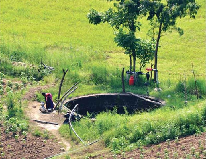
Institutional Analysis and Landscape Level Planning Guidelines for Watershed Development in India
CHALLENGE
Improved watershed management will be crucial to meet growing food demand in India, for example by: recharging local aquifers and improving downstream water flows; decreasing soil erosion; increasing agricultural productivity; and helping farmers adapt to climate change. Experts believe that an additional 102 million tons of food grains need to be produced annually by 2020 to meet national nutritional needs under moderate population growth forecasts, 38 million tons of which will need to come from either rainfed lands or imports.
However, rainfed regions have lagged far behind and have experienced severe resource degradation due to inappropriate land use, poor husbandry and low investments. Longer-term climate change adds another worrying dimension. Climate change requires new adaptation measures by farmers, especially small and marginal farmers who are the most vulnerable to these forecast impacts.
The Integrated Watershed Management Program (IWMP), financed through the Department of Land Resources, currently forms the cornerstone of the Government of India's support to watershed development, covering 27 states and proposing to invest over US$6.6 billion through a 10-year period to 2017. Besides the IWMP, a number of other centrally financed schemes are related to watershed management, agriculture and rural livelihoods, which to varying degrees address development needs in rainfed areas. The IWMP has been slowly rolling out and expanding its reach across India since 2009. But, it has not delivered expected results evenly across the country or to the desired levels. In moving forward to improve the IWMP model and execution, a number of key issues outlined recently by the Planning Commission and various other reports/experts have been identified.
Two key issues are:
Fragmented programming and partial solutions. Given their ecological characteristics, developing rainfed areas requires a broad watershed approach. Large budgets are now available for IWMP and several other schemes for the development of rainfed areas within the Ministry of Rural Development. However, each of these is conceived and implemented in departmental silos without unified mechanisms for coordination and convergence. As a result, these programs do not lead to area development, potential synergies are lost, and investments, interventions, and results remain sub-optimal.
Narrow planning scale. The IWMP is executed through clusters of micro-watersheds (each usually 500 ha to 700 ha) covering an average of 5,000 ha. This scale is appropriate for participatory planning and implementation communities. However, a larger landscape assessment/planning framework ranging up to 25,000 ha is also needed where broader land and water issues can be identified, and a more coordinated approach developed to converge government schemes with the IWMP. The current IWMP model also does not fully incorporate surface and groundwater assessments into management and monitoring activities to guide integrated planning at sub-watershed and micro-watershed scales.
APPROACH
This activity aims to address some of the issues above by helping to:
- Improve intra- and inter-ministerial convergence in watershed management in India;
- Develop landscape level catchment assessment/planning methods and guidelines for India; and
- Disseminate knowledge on good practices in watershed management building on a draft report prepared under a previous PROFOR activity.
RESULTS
The activity was successfully completed. The final report “Catchment Assessment and Planning for Watershed Management” is now available to the left along with a summary report. A launch workshop was held in Washington, D.C., in October 2014. A similar workshop was held in Delhi in December 2014. One article based on this work was published in a national journal in India. In addition, the “Operational Guidelines for Benchmarking Watershed Management Outcomes” prepared by the Ministry of Rural Development of India and the World Bank discussion paper “Watershed Development in India: An Approach Evolving through Experience” can be downloaded from this page.
Some key insights and lessons are:
- Micro-watersheds are the appropriate scale for program implementation with communities, with guidance by larger scale catchment assessments.
- Decentralized and participatory development is a necessary approach for success.
- Invest in participatory, evidence-based micro-watershed plans with communities.
- Invest in capacity building and information sharing to build sustainability and a body of knowledge.
- Invest in comprehensive monitoring and evaluation (M&E) to track implementation and support management.
For stories and updates on related activities, follow us on twitter and facebook , or subscribe to our mailing list for regular updates.
Author : World Bank
Last Updated : 06-16-2024
Share
External Related Links
Attachments
INNOVATIVE%20FINANCING%20FOR%20SUSTAINABLE%20FOREST%20MANAGEMENT_0.pdf
Keywords
Authors/Partners
World Bank, SNV Netherlands Development Organization, Natural Resources Solutions consultancy - Kosovo, REGEA Croatia, Diava Consulting - Albania, Faculty of Forestry - Macedonia, Wageningen University - The Netherlands
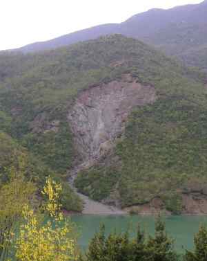
Innovative Financing for Sustainable Forest Management in the Southwest Balkans
CHALLENGE
In many countries—particularly in the Balkans—most of the environmental services provided by the sustainable management of forests and uplands are seldom quantified, often not valued, and even more rarely captured by the owners/managers of these resources. Capturing these benefits has the potential to enhance the environmental management of forest resources, protect landscapes from erosion and downstream water systems from siltation and flooding, increase carbon sequestration (with a possible decrease in consumption of fossil fuels), while at the same time helping to address rural poverty.
To increase the likelihood of payment for these environmental services, the value and scale of the benefits generated need to better understood.
APPROACH
With support from multiple partners including PROFOR, the World Bank’s Europe and Central Asia staff is undertaking two case studies to assess:
- the benefits of sustainable upland forest and land management for downstream water users, and
- the effectiveness of increasing the use and efficiency of firewood in reducing the use of fossil fuels and hence greenhouse gas emissions.
The first case study focuses primarily on the Ulza hydro-power dam and watershed in Albania. The second case study looks mainly at wood supply, stoves, and heating systems in Kosovo.
This research aims to define scientifically sound methodologies; establish key baseline data in some case studies; provide quantitative estimates of the value of specific targeted environmental services; propose mechanisms to start or increase payment for these services in the two countries; and then disseminate the results and experience both regionally and more broadly. The results will be particularly helpful for countries in the process of European Union accession, as they develop agro-environmental payments within the common agriculture policy.
RESULTS
All field work and data collection activities for the two case studies have concluded. Thirty-two project publications have been translated into Albanian and disseminated through the project website http://www.cnvp-wbprofor.org/home.html, the project blog http://wbprofor.blog.com, and the project Facebook page. The main publication Study and Analysis of Innovative Financing for Sustainable Forest Management in the Southwest Balkan: Innovative Financing for Sustainable Forest Management (September 2013) is also available on PROFOR website. A series of stakeholder workshops was held in Albania and Kosovo. The final results workshop for Albania took place in September 2013 in Tirana, and the final results workshop for Kosovo occurred on in Prishtina the same month.
FINDINGS
The project generated numerous findings that are detailed in the project publications. Highlights include the following:
Albania
-At least 31.5% of the Ulza reservoir storage is filled with sediment.
-Erosion and sediment are correlated to land uses in a measurable way, with forested areas producing the lowest sediment load.
-Around 12% of stakeholders in the watershed are willing to pay for environmental services such as reduced erosion and reduced sedimentation.
Kosovo
-Total wood biomass production is about 1.25 million cubic meters, of which 0.17 million cubic meters is legally harvested forest.
-95% of wood harvested from forests is used for firewood.
-Improving existing agroforestry sites and introducing fast-growing species are good opportunities to increase wood biomass production.
-Wood biomass is an economically attractive energy option for individual household heating and public buildings.
-Carbon markets could support energy production from wood biomass.
This activity is ongoing. A website dedicated to sharing the results of this activity has been set up at the following address: http://www.cnvp-wbprofor.org/home.html.Key findings and reports will also be shared on this page. You can also follow us on twitter (www.twitter.com/forestideas) or subscribe to our mailing list for regular updates.
For stories and updates on related activities, follow us on twitter and facebook , or subscribe to our mailing list for regular updates.
Author : World Bank, SNV Netherlands Development Organization, Natural Resources Solutions consultancy - Kosovo, REGEA Croatia, Diava Consulting - Albania, Faculty of Forestry - Macedonia, Wageningen University - The Netherlands
Last Updated : 06-16-2024
Share
External Related Links
The Economics of Climate Change in LAC (2010)
Attachments
web%20brasil_2030_portugues_0.pdf
Keywords
Authors/Partners
A multidisciplinary and multi-agency team comprising leading experts from the Brazilian National Agricultural and Forestry Research Agency (EMBRAPA), the University of Campinas (UNICAMP) in Sao Paulo, the Brazilian Agency for Space Research (INPE), and the Brazilian Institute for International Trade Negotiations (ICONE), a major think-tank.Erick Fernandes, Adviser, Climate Change and Natural Resource Management, World Bank (Latin America and Caribbean), managed and oversaw the program.
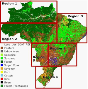
Impacts of Climate Change on Rural Landscapes in Brazil
CHALLENGE
There is growing concern that Brazilian agriculture and forestry sectors are increasingly vulnerable to climate variability and change (eg. a decline in productivity of subsistence crops in northeastern Brazil; increased risk of fire and Amazonian forest dieback). To meet development, food security, climate adaptation and mitigation, and trade goals over the next several decades, Brazil will need to significantly increase per area productivity of food and pasture systems in central and southern Brazil while simultaneously reducing deforestation, rehabilitating millions of hectares of degraded land for cropping and forest plantations in the Amazon, the cerrado, the Atlantic forest, and the Pampas.
However, because of previous climate modeling and data limitations, there was still significant uncertainty associated with the projections for Amazonian rainfall (timing, seasonality) as well as the magnitude and locations of climate impacts in Brazil over the next 50 years. Improved climate change impact assessments were urgently needed to guide policy makers on priorities, geographical targeting (hot spots), and phasing of investments for adataptation and mitigation to climate change.
APPROACH
This activity implemented by the World Bank in partnership with leading Brazilian agencies and supported by PROFOR focused on establishing a robust and integrated decision and policy support framework that could empower Brazil’s policy makers and the agricultural sector to undertake the adaptation necessary to cope with projected climate change.
Its objectives were:
- 1.To refine the available climate change projections for Brazil via the coupling of global, regional, and local scale modeling currently being tested by the Brazilian National Institute for Space Research (INPE) in Brazil and the regional climate program for South America (CREAS).
- 2. To integrate the INPE and CREAS suite of tested global (300 km horizontal resolution) and regional models (50 km horizontal resolution) with the state of the art Brazilian developments in Regional Atmospheric Model (BRAMS) that incorporates aerosol and land cover/deforestation/burning feedbacks for much improved local weather and climate (especially rainfall) projections.
- 3. To make the Brazilian Agro-Eco Zoning Model that is currently used by the Central Bank of Brazil for rural credit programs "climate-smart" by integrating the high resolution climate projection outputs from 1 and 2.
- 4. To make the existing Brazilian Land Use Model (BLUM) climate-sensitive by coupling it with the outputs described above to assess: (a) Climate change induced changes in supply and demand of agricultural commodities at a national level, (b) Changes on the distribution of land use and production (agriculture, forestry, pasture) in Brazil for given supply and demand scenarios, and (c) Economic effects on agricultural and forestry production and profitability.
RESULTS
Projections for land use and forest land cover change, and an assessment of the distribution of land use and production were undertaken. Specifically, previous climate change projections were refined using a global, regional and local scale modeling; Regional Climate Change Scenarios for South America (CREAS) were used for regional and sectoral impact assessments; the Agro Climatic Risk and Vulnerability Zoning Model developed by EMBRAPA and UNICAMP was refined; soils were classified and cropping areas that are less vulnerable to climate change impacts were identified based on temperature effects through 2020 and 2030. A final report, in English and Portuguese, is forthcoming.
FINDINGS
The study showed that while for some crops (soybean and cotton) the projected negative climate impacts to 2020 are likely to be more moderate than previously projected, for other crops (beans and corn), however, the impacts could be significantly more severe than projected in previous studies. All the climate change scenarios simulated in this study resulted in a reduction of ‘low risk’ cropland area in 2020 and 2030.
More specifically, the findings suggested that the South Region of Brazil, currently an agricultural powerhouse, could potentially lose up to 5 million hectares (ha) of its highly suitable agricultural land due to climate change, while Brazil as a whole could have around 11 million ha less of highly suitable agricultural land by 2030. The findings of this study are being incorporated by EMBRAPA into the EMBRAPA/UNICAMP Agroecozone Model to improve the climate projections that underpin the national rural credit and insurance programs in Brazil.
Read the report in Portuguese.
Follow us on twitter and facebook or join our mailing list for regular updates.
For stories and updates on related activities, follow us on twitter and facebook , or subscribe to our mailing list for regular updates.
Author : A multidisciplinary and multi-agency team comprising leading experts from the Brazilian National Agricultural and Forestry Research Agency (EMBRAPA), the University of Campinas (UNICAMP) in Sao Paulo, the Brazilian Agency for Space Research (INPE), and the Brazilian Institute for International Trade Negotiations (ICONE), a major think-tank.Erick Fernandes, Adviser, Climate Change and Natural Resource Management, World Bank (Latin America and Caribbean), managed and oversaw the program.
Last Updated : 06-16-2024
Share
External Related Links
Documentary on Rwanda's efforts to plan for climate change (John Liu, hosted on Youtube)
CIFOR Blog: Adaptation research needed to fill gaps
Attachments
Uso de los bosques para aumentar la capacidad de adaptación al cambio climático _0.pdf
PROFOR_Brief_HondurasLow_0.pdf
PROFOR_WrkingPaper_Honduras_0.pdf
PROFOR_Brief_Honduras_ESP (00000003)_0.pdf
Country case study - Burkina Faso_0.pdf
Keywords
Authors/Partners
CIFOR, Trust Fund for Environmentally and Socially Sustainable Development, PROFOR
How Forests Enhance Resilience to Climate Change
CHALLENGE
Developing countries are expected to suffer the most from changes in climatic patterns. The effects of climate change, including higher temperatures, changes in precipitation patterns, rising sea levels and increased frequency of weather related disasters are bound to create risks for agriculture, food, and water supplies. International and national discussions on forests and climate change have largely been focused on reducing emissions from deforestation and degradation and enhancing carbon stocks (REDD+).
Less obvious, yet equally important, is the role of forests in enhancing landscape resilience to climate change—for example at the scale of a watershed. Forests and trees provide environmental services ranging from increasing water quality and quantity in well defined areas, reducing soil erosion, creating micro-climatic conditions that maintain (or in some cases improve) productivity. The sustainable management of forests can also strengthen social resilience, by offering a diversification of revenue sources and product supplies, and building the capacity of local and national institutions.
Forest and tree management could provide a low-cost approach to enhancing resilience of local landscapes to climate change but needs to balance production, livelihood, adaptation and mitigation goals.
PROFOR is conducting a study to improve our understanding of the role of forests in improving the climate resilience of other sectors (mainly agriculture, water, social and biomass based energy sectors). The goal is to inform national adaptation strategies so that they explicitly reflect the value of forest and allocate appropriate resources to facilitate the use of forests for adaptation.
This study will:
• Map forest management approaches and their cross-sectoral impacts
• Identify interactions between forest sector adaptation (or existing management) and resilience enhancement in other sectors (mainly water, biomass-based energy, and agriculture)
• Assess the institutional and financial requirements to identify and implement tree/forest-based adaptation measures
• Identify ways of supporting local knowledge and science that promote tree/forest based adaptation measures with multi-sectoral benefits
RESULTS
The state of knowledge report, synthesis report and case studies are now complete. Briefs for each case study will be available for download soon (the Honduras case study is already available at left in English and Spanish.
For stories and updates on related activities, follow us on twitter and facebook , or subscribe to our mailing list for regular updates.
Author : CIFOR, Trust Fund for Environmentally and Socially Sustainable Development, PROFOR
Last Updated : 06-15-2024
Share
External Related Links
Learn more: MIT team describes unique cloud forest in Oman (Sept. 2006)
Attachments
CloudForests_Adapting_Climat_Change_0.pdf
Keywords
Authors/Partners
Professor Elfatih A. B. Eltahir (Massachusetts Institute of Technology, MIT). World Bank Middle East North Africa region.
Desert Cloud Forests in Yemen and Oman
CHALLENGE
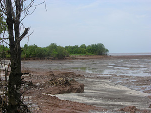
Desert Cloud Forests in Yemen and Oman are unique and fragile ecosystems, subject to human threats and climate change repercussions.
They are a remnant of the moist vegetation belt that once spread across the Arabain Pensinsula when the climate was generally wetter, and are host to precious biodiversity. They also represent a safety net for the local population who relies on these forests (kept alive by extracting water droplets from low-lying passing clouds) for wood collection and geazing land. However development pressure in terms of deforestation and uncontrolled grazing represents a serious risk.
APPROACH
This activity, put forward by the World Bank's Middle East and North Africa region in May 2010, proposed to:
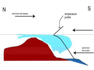
1) improve understanding of the mechansims behind the unique environment of the Desert Cloud Forests in Yemen (Hawf region) and Oman (Dhofar region);
2) explore the dependency of the relationships and interactions between the local poor population and the forests both in terms of benefits and threats. Surveys and consultations would rely partly on the Poverty Forests Linkages Toolkit sponsored by PROFOR.
3) develop proposals for sustainable integrated forest management that would benefit both the Cloud Forests and the welfare of local communities that depend on them, keeping in mind climate uncertainties. Identification of these options will be based on the results of the scientific and field analyses mentioned above as well as best practices from outside the region.
RESULTS
Because political instability in Yemen prevented the team from conducting fieldwork, this activity was closed prematurely at the end of 2011. A report assessing the scientific background of the Desert Cloud Forests, which was prepared by Prof. Elfatih A. B. Eltahir (Professor at the Massachusetts Institute of Technology, MIT) under this PROFOR grant, is available in draft form on this web page.
The report concludes that an increase in animal population is degrading the natural ecosystem in many locations (camels browsing on tree canopies). As for climate change, the main hazard to the desert cloud forest of Oman and Yemen is the scenario of an upward shift in cloud cover and fog during summer; however, that scenario is very uncertain and increased cloud frequency is also a possibility.
For stories and updates on related activities, follow us on twitter and facebook , or subscribe to our mailing list for regular updates.
Author : Professor Elfatih A. B. Eltahir (Massachusetts Institute of Technology, MIT). World Bank Middle East North Africa region.
Last Updated : 06-15-2024